


Where is the Europort Barrier located?
After the decision was taken that a barrier had to be installed in the Europort area, the location had then to be decided. There proved to be many possibilities. The various possible locations were evaluated in terms of reliability, shipping traffic, technological requirements, time, cost and wider social considerations such as harmonisation with the landscape and implications for commercial activity.
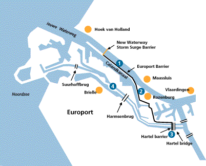
1. Construction of 1-meter high dyke on the Rozenburg peninsula from the southern abutment of the New Waterway Storm Surge Barrier towards Rozenburg.
2. Reinforcement of the southwestern portion of the water defense system around Rozenburg. Elevation of existing dyke. The Europort Barrier then runs from Rozenburg across the Botlekweg. At the Welplaatweg the barrier joins up with the A15 via the eastern slope.
3. The route then runs to the Hartel Bridge. In the vicinity of the bridge a moveable storm surge barrier - the Hartel Barrier - is built in the Hartel Canal. The Hartel Locks are fitted with new lock- gates and new operating equipment and the outer head is elevated. The number of temporary mooring sites for vessels is increased. The Hartel Barrier is also fitted with a guard in order to protect the barrier from large and heavy floating debris, such as empty containers. In addition a new control building is added to operate the barrier and the lock.
4. The Brielse Maas Dyke has to be elevated by 2.5-3 meters between the Hartel Barrier and the Suurhoff Bridge. Pipeline crossings in the Brielse Maas Dyke are modified. Bank and toe protection are extended both upwards and downwards.