[ Construction Date ] 1624
This was the earliest fort built in Taiwan. Today there remains only part of one wall, a well, the semicircular base of a lookout tower, and the outer wall of what was once Fort Utrecht.
Construction on the site began in 1624 and was completed ten years later, in 1634. The fort was built on an offshore shoal at Yi-k'un-shen.At first known as Fort Orange, the name was subsequently(1634) changed to Fort Zeelandia. Bricks were brought from Java for its construction. The fort wall was over 30 feet high, with a circumference of some 2776 feet. The fort was further defended by an outer wall three feet high. The whole structure was three storeys high and had a grand appearance. It was the residence of the governor-general and the point from which the Dutch controlled administration during their occupation of Taiwan. When the Dutch were expelled by Koxinga in 1662, the site-name was changed from Yi-k'un-shen to An-p'ing, 'Calm Peace,' sometimes also known as 'the City of the Prince'(a reference to Koxinga's status). In 1683, when Taiwan was brought under the jurisdiction of the Ch'ing government, the administrative center was shifted to nearby Tainan City. The fort then became the Bureau of Military Supply. In 1871, when the British invaded Taiwan, the arsenal inside the fort exploded, destroying the walls. What was left of the bricks and masonry was pillaged by the people to be used as construction materials for their own houses. In 1874 building materials for the Erh-k'un-shen Fort built under the direction of Shen Pao-chen were also taken from this site. During the Japanese occupation period, surviving wall remnants were levelled to the ground, the steps rebuilt, and a smaller enclosure wall added, forming an elevated rectangular battlement. This enclosure is now known as the 'Old An-p'ing Fort.'
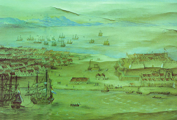
Detail from a view of the fort published in an early Dutch document. Visible are both Chinese and European ships. Body of water at upper left is the T'ai-chiang inland sea. On the far right are numerous shoals. The fort itself was built upon a tiered platform; its layout was divided into upper and lower sections.
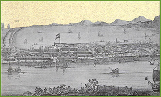
A later Ch'ing reconstruciton of the fort.
Clear seen is the layout of the houses inside the fort. The village seen to the left of the enclosure developed into today's An-p'ing District.
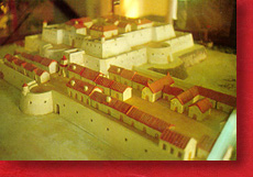
Model of the Old Tainan Fort designed for a recent exhibition.
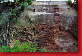
Surviving remnant of Old Tainan Fort is part of the former south enclosure wall, which was built on a massive scale, paved with slightly thinner bricks. The mode of masonry in undertaken after a Dutch bond.
![]()