Dominica Online
at the Internet World Exposition 1996
The Basics
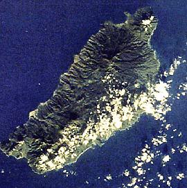
It has several peaks of over 3,000', the tallest of which are Morne Diablotin (4,747') and Morne Trois Pitons (4,600').
Dominica is perhaps most famous for its tropical rainforest, and the many rivers and waterfalls which result from the high rainfall in the interior. In addition, its volcanic origins manifest themselves most noticably in the Boiling Lake (one of the largest of its kind in the world) and many other smaller fumaroles around the island (including at least one underwater). Moreover, it is widely acknowledged to be both one of the best dive sites and a prime whale watching location in the region (if not world).
There are a number of National parks or reserves on the island. The 17,000 acre Morne Trois Pitons National Park contains perhaps the majority of Dominica's above-water famous sights - several crater lakes and waterfalls, including the Emerald Pool.
The Northern Forest Reserve is another fine example of oceanic rainforest and is also famous as the home of Dominica's national bird, the rare Sisserou Parrot. The Cabrits National Park, just north of Portsmouth, is home to the partly-restored Fort Shirley. It is also a marine reserve, and it is hoped the area around Scott's Head/Soufriere at the south-western tip of the island will also be declared a marine reserve in the near future.
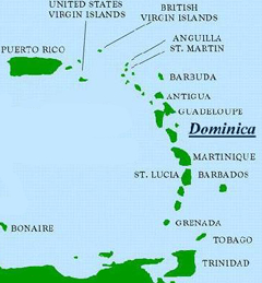
Dominica's population is around 71,000, of which 20,000 live around the capital city, Roseau (pronounced 'Ro-zo'), which is located on the south-west coast. The second largest city is Portsmouth in the north-west. Other 'conurbations' of note include Marigot in the north-east, and Grand Bay in the south.
English is the official language but a French-based Creole (kwéyňl) is widely spoken, especially in outlying villages. This reflects an often turbulent history in which the island would be assigned to Britain by a treaty with the French, who would promptly break it and try to regain control of Dominica. Throughout and to the present day the original inhabitants, the Caribs, tried to coexist. In 1903 they were assigned a 3,700 acre Territory in the north-east where around 3,000 live today.
The original Carib name for Dominica is Waitikubuli
The currency is the Eastern Caribbean Dollar (of which there are 2.7169 to the US$). Banking hours are Monday to Friday, 8am to 3pm (Friday till 5pm).
The close season for game and freashwater fish, which includes agouti, crabs, crayfish, crapaud ('Mountain Chicken') and manicou is from March 1 through August 31. Other regulations visitors should bear in mind is that the import and export of fruit, vegetables and flowers is restricted; you will need to obtain a license to take out flowers, for example.
The New Market, at the other end of the Bayfront, comes alive early Saturday morning (but is also open other week days) with a stunning variety of tropical fruits, vegetables, flowers and sundry items. Be sure also to take a refreshing drink of coconut water while there.
The 'crushed bus' in the Botanical Gardens is a silent testimony to the force of the winds of Hurricane David (1979), and also the the regenerative power of nature (the tree is still growing, on top of the bus). Look out for the 'bamboo house', and nearby a small aviary with examples of Dominica's rare parrots. High above the aviary is a fine vantage point, Morne Bruce, which can be reached from a track near the east gate, and provides a splendid view of Roseau.
Leaving the Gardens via the west gate, go straight and you'll soon pass Tropicrafts (look in to see the mats being made) and see the Roman Catholic Cathedral on your left. A little lower down, turn left on to King George Street and look out for the Kalinago Centre, which has a good collection of information, photos and art about and by Dominica's Caribs.
Dominica's second city is Portsmouth, situated in the north-west of the island on Prince Rupert Bay.
For visitors, the focal point is The Cabrits, a headland on which can be found the remains of the recently restored Fort Shirley. Wander around the headland and you'll probably stumble on old buildings and cannon from the Fort. And it's all free.
Also of note is the Indian River, where you can take a boat ride up through the mangroves for about a mile.
At the end of the island, the villages of Soufriere and Scott's Head are both on the same beautiful bay. Scott's Head is at the end of a short isthmus and affords a brilliant view of the bay, north along the coast, and south to Martinique if the weather is good. On the Head are the ruins of Fort Cachacou which was an important defence post and involved in action between the British and French in 1778 and 1805.
As the name implies, Soufriere is home to more sulphur springs. Also of note is a fine vantage point over looking the bay at the village of Gallion above Soufriere.
From the US, American Eagle flies direct into Melville Hall from San Juan. American Airlines also flies via San Juan into Antigua . From Antigua, Barbados and St. Lucia the regional carrier LIAT connects to both Canefield and Melville Hall. British Airways also flies into Antigua, St. Lucia and Barbados. Air France connects via Martinique and Gualeloupe.
To get the best view: flying north into Canefield Airport (from for example, St. Lucia), sit on the right of the aircraft. Flying south (from Antigua), sit on the left. Sit on the opposite side if flying into Melville Hall Airport. This tip will give you superb views of the island!
Melville Hall to Roseau US$16.00 per person Melville Hall to Portsmouth US$12.00 per person Canefield Airport to Roseau US$8.00 per person Canefield Airport to Portsmouth US$43.00 per person Rates are subject to official change |
There are three main sea ports. Woodbridge Bay is one mile north of Roseau; both the Roseau Ferry Terminal and the Cruise Ship Berth are located on the Bayfront of Roseau itself, within close proximity to the business and shopping areas of the capital.
L'Express Des Iles is an inter-island high-speed catamaran service connectng Dominica to both the neighbouring French islands and St. Lucia. There is a EC$20.00 port Departure Tax.
| Mean Air Temperatures | |
| Maximum | 29.6 Celcius |
| Minimum | 24.2 Celcius |
| Avg. Monthly Rainfall (mm) | |
| Marigot | 248.1 |
| Canefield | 126.8 |
| Avg. Sunshine per day: | 7.4 hours |
| Wettest/Driest Months (1994/95, in mm) | ||
| Wettest | Driest | |
| Roseau 1994 | Sep (374) | Mar (22.5) |
| 1995 | Aug (545) | Mar (42) |
| Portsmouth 1994 | Sep (529) | May (38.5) |
| 1995 | Nov (918) | May (45) |
| Petite Coulibri 1994 | Sep (361) | Mar (40.6) |
| 1995 | Aug (489) | Jun (44) |
| Vielle Case 1994 | Sep (573) | Jun (102) |
| 1995 | Aug (584) | May (38) |