The phase of development of the Champlain Sea that followed the initial Charlesbourg Phase is referred to as Phase 2. It encompasses the history of the Champlain Sea from the time it broke through the ice barrier just upstream from Quebec (12ka) until retreat of the ice from the Saint-Narcisse Moraine (10.8ka). During this period, marine waters replaced Lake Candona in the main basin of the Champlain Sea and the Laurentide Ice Sheet withdrew from the St. Lawrence Lowland.
The onset of the marine invasion in the main Champlain Sea Basin is defined stratigraphically at Riviere Landry. 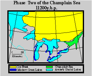 Along the Applachian piedmont, between Valcourt and Warwick, water levels fell from 230 m a.s.l. to about 170 m a.s.l. as a result of opening to marine waters. Similar drops of water-levels were also recognized further southwest along the Appalachian piedmont, and at the foot of the Adirondacks. The microfaunal record at Riviere Landry and the sudden fall of water levels suggests that glaciolacustrine waters were replaced by marine waters almost instantaneously, around 12ka, in the Appalachian piedmont, southwest of Victoriaville.
During the later part of Phase 2 of the Champlain Sea, the retreating Laurentide Ice Sheet formed the Saint-Narcisse Moraine. This complex of morainic ridges was deposited near the southern margin of the Laurentian Highlands over a distance of 500km between the Gatineau River, north of Otawa, and Saint-Simeon, in the Charlevoix region. The Stratigraphic record shows that the base of the Sait-Narcisse morainic complex inthe lower Saint-Maurice region is composed of proximal and distal glaciomarine deposits containing Portlandia arctica and Balanus hameri, dated between 11.3ka and 11.1ka. This moranic complex was apparently deposited at a grounded ice margin that stabilized at the contact zone between the sheild and the sedimentary platform. The possibility that the ice may have readvanced from a more northerly position is not excluded. The margin of the Laurentide Ice Sheet may have extended into the Champlain Sea at this place because of glacial streaming within the Saint-Maurice lobe. Consistent south-southeast trend of glacial striae throughout the upper Saint-Maurice Valley suggests that ice was channelled between the Mont Tremblant highlands to the west and the Parc des Laurentides highlands to the east. As a consequence, around 11ka, the Saint-Maurice lobe of the Laurentide Ice Sheet was dynamic enough in the Saint-Maurice Valley to maintain a 150km long marine front. The occurrence of compression structures in melt-out till within the morainic complex suggests that the ice front remained active and grounded (Parent & Occhietti, 1988). the end of the Saint-Narcisse episode marked the beginning of Phase 3 of the Champlain Sea.